Overall SDG Alignment Evaluation:
The Bachelor of Science Program in Geoinformatics at Khon Kaen University is engineered to produce graduates who can integrate geoinformation science and technology for sustainable development. The program's philosophy emphasizes creating professionals skilled in spatial analysis, data management, and the application of modern technologies like Remote Sensing and GIS to solve complex problems related to natural resources, the environment, disaster management, and urban planning. This curriculum is a powerhouse for SDGs related to environmental stewardship, particularly SDG 11 (Sustainable Cities and Communities), SDG 13 (Climate Action), SDG 14 (Life Below Water), and SDG 15 (Life on Land). Courses on urban planning, smart city development, natural resource management, and disaster management provide students with the exact tools needed to monitor ecosystems, plan sustainable urban growth, and build resilience to climate-related hazards. Furthermore, the program is a key enabler of SDG 9 (Industry, Innovation, and Infrastructure), as geoinformatics is a critical technology for modern infrastructure planning and management. It also supports SDG 6 (Clean Water and Sanitation) through applications in watershed management. As a higher education program, it is a direct contributor to SDG 4 (Quality Education), and its emphasis on real-world projects and cooperative education fosters the multi-stakeholder collaboration essential for SDG 17 (Partnerships for the Goals).
Best Practices
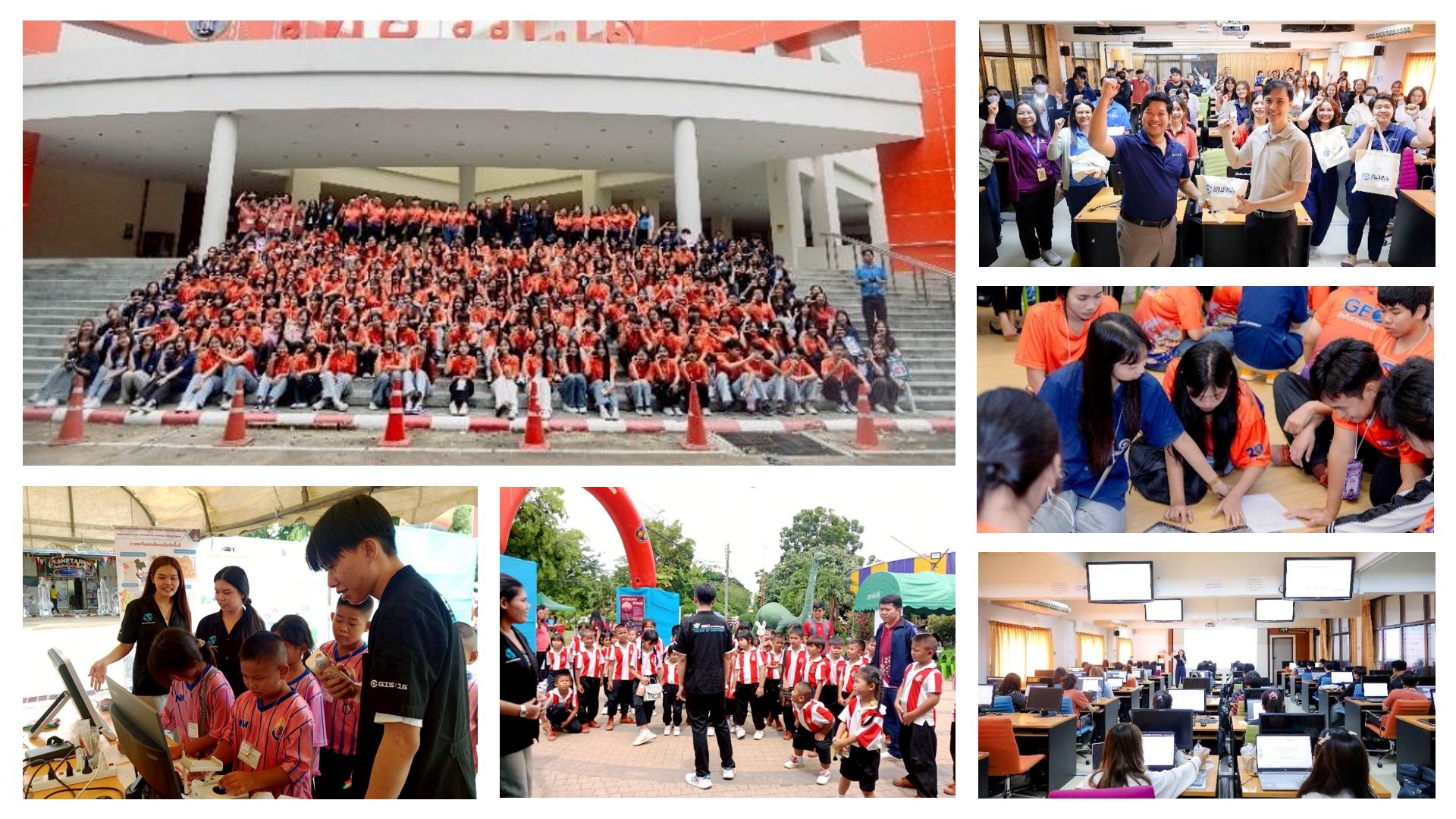
The Master of Science Program in Geoinformatics, College of Computing, Khon Kaen University (KKU), recognized its vital role as an academic and innovation leader in driving sustainable regional development. Thus, it organized the workshop activity "Utilization of Data in API Format to Extend the Prototype System for Applying Digital Twin Technology."
This integrated advanced knowledge from core Geoinformatics courses, such as Spatial Data Management and GIS Analysis, with practical learning to solve the challenges of Smart Cities development through cooperation with experts from GISTDA. The activity focused on reinforcing skills in applying GeoSpatial Digital Twins technology, data linking via API, utilizing GISTDA Map Maker, and creating three-dimensional (3D) spatial Dashboards using Open GeoSpatial Data for 63 students in the Geoinformatics program at the 3rd-4th year level.
The evident result is the elevation of students' capabilities to effectively create a prototype system for analyzing and presenting complex spatial data. This signifies the transition from theoretical learning to becoming "Potential Geoinformaticians" ready to meet the demands of the digital era industry.
The sustainable impact of this activity is the production of high-technology expert personnel who can use spatial data as a tool for flexible and equitable urban design and management, thereby laying a crucial foundation for the development of the nation's digital infrastructure and innovation.
This operation is aligned with and serves as a key driving mechanism for three Sustainable Development Goals (SDGs): SDG 9: Industry, Innovation, and Infrastructure (by promoting research and innovation through the development of spatial applications and Digital Twins technology), SDG 11: Sustainable Cities and Communities (by using Geoinformatics tools to support sustainable Smart City planning and management), and SDG 4: Quality Education (in ensuring learners receive advanced technical skills that are demanded by the labor market in the 21st century).
Alignment Summary: This program provides high-quality, specialized tertiary education in a cutting-edge scientific field. It ensures students acquire the technical, vocational, and research skills necessary for employment and lifelong learning in the geospatial industry through a curriculum that includes research projects and mandatory professional experience.
| Course Code | Course Title | Alignment Rationale |
|---|---|---|
| CP 374 892 | Research Project | Represents a capstone lifelong learning opportunity, equipping students with advanced research skills that are highly relevant for employment and innovation in the geoinformatics sector (Target 4.4). |
| CP 374 894 | Cooperative Education | Provides mandatory and extensive work placement, ensuring all students acquire technical and vocational skills for employment, directly supporting lifelong learning opportunities (Target 4.3 & 4.4). |
Alignment Summary: The curriculum contributes to the sustainable management of water resources. Students learn to use geospatial technologies to analyze watersheds, monitor water quality, and manage water-related ecosystems, supporting community-based water management and conservation efforts.
| Course Code | Course Title | Alignment Rationale |
|---|---|---|
| CP 373 342 | Geoinformatics for Natural Resources and Environmental Management | Directly supports the protection and restoration of water-related ecosystems by teaching students to apply geospatial analysis to watershed management and water resource monitoring (Target 6.6). This also aligns with community participation in water management (Target 6.B). |
Alignment Summary: By equipping students with high-demand skills in a technology-driven field, the program promotes job creation and economic productivity. Graduates are prepared for careers that contribute to innovation and the development of a knowledge-based economy, fostering sustainable economic growth.
| Course Code | Course Title | Alignment Rationale |
|---|---|---|
| CP 374 894 | Cooperative Education | Provides students with significant work experience, supporting the achievement of full and productive employment and facilitating the transition of youth into the workforce (Target 8.6). |
Alignment Summary: The entire field of Geoinformatics is a driver of innovation. This curriculum provides the core competencies for developing and utilizing geospatial technologies, which are essential for building resilient infrastructure, promoting sustainable industrialization, and enhancing scientific research across numerous sectors.
| Course Code | Course Title | Alignment Rationale |
|---|---|---|
| CP 372 231 | Geographic Information System | Provides foundational skills for developing and managing the spatial data infrastructure that is critical for modern industry and sustainable development (Target 9.1). |
| CP 373 331 | Geographic Information System Application Development | Enhances scientific research and technological capabilities by teaching students to build innovative applications that solve industrial and societal problems (Target 9.5). |
| CP 373 112 | Mapping with Unmanned Aerial Vehicle | Fosters innovation by providing skills in emerging technologies for data acquisition, which supports the upgrading of technological capabilities in various industries (Target 9.4). |
Alignment Summary: This program is directly aligned with creating sustainable cities and communities. It provides students with the specific skills needed for urban planning, smart city development, and managing cultural and natural heritage, thereby contributing to making human settlements inclusive, safe, resilient, and sustainable.
| Course Code | Course Title | Alignment Rationale |
|---|---|---|
| CP 373 341 | Geoinformatics for Urban and Regional Planning | Directly addresses integrated and sustainable human settlement planning and management through the application of geospatial technologies (Target 11.3). |
| CP 373 444 | Geoinformatics for Smart City | Focuses on developing the technological solutions needed for smart and sustainable urban development, contributing to inclusive and sustainable urbanization (Target 11.3). |
| CP 373 342 | Geoinformatics for Natural Resources and Environmental Management | Supports efforts to protect and safeguard cultural and natural heritage by providing tools to monitor and manage these assets, a key component of the 'Sustainable practices' metric (Target 11.4). |
Alignment Summary: The program provides essential tools for climate action. Students learn to use remote sensing and GIS to monitor climate-related hazards, assess vulnerability, and plan for adaptation, which strengthens resilience and adaptive capacity to climate change.
| Course Code | Course Title | Alignment Rationale |
|---|---|---|
| CP 373 442 | Geoinformatics for Disaster Management | Directly contributes to strengthening resilience and adaptive capacity to climate-related hazards and natural disasters (Target 13.1). |
| CP 372 211 | Introduction to Remote Sensing | Improves education and awareness-raising on climate change impact reduction and early warning through the use of satellite imagery and data analysis (Target 13.3). |
Alignment Summary: The curriculum supports the conservation of marine and coastal ecosystems. Geospatial technologies taught in this program are crucial for monitoring coastal erosion, mapping marine habitats, and managing marine resources sustainably, thereby contributing to the health of life below water.
| Course Code | Course Title | Alignment Rationale |
|---|---|---|
| CP 373 342 | Geoinformatics for Natural Resources and Environmental Management | Provides the tools and techniques to sustainably manage and protect marine and coastal ecosystems from land-based activities (Target 14.1 & 14.2). |
Alignment Summary: This program is essential for the sustainable management of terrestrial ecosystems. Students learn to apply geoinformatics to monitor deforestation, manage forests, combat desertification, and conserve biodiversity, directly contributing to the protection and restoration of life on land.
| Course Code | Course Title | Alignment Rationale |
|---|---|---|
| CP 373 342 | Geoinformatics for Natural Resources and Environmental Management | Directly supports the conservation, restoration, and sustainable use of terrestrial and inland freshwater ecosystems, including forests and mountains (Target 15.1). |
| CP 373 211 | Remote Sensing of the Environment | Provides skills to monitor ecosystems and biodiversity, which is crucial for taking action to halt biodiversity loss (Target 15.5). |
Alignment Summary: Geoinformatics is a collaborative field that relies on data sharing and partnerships between government, academia, and the private sector. This program fosters these partnerships through cooperative education and project-based learning, preparing students to work in multi-stakeholder environments to achieve the SDGs.
| Course Code | Course Title | Alignment Rationale |
|---|---|---|
| CP 374 894 | Cooperative Education | Represents a direct multi-stakeholder partnership between the university and industry, mobilizing and sharing knowledge and technology for sustainable development (Target 17.16 & 17.17). |
| CP 374 801 | Seminar | Promotes knowledge-sharing and dialogue on best practices in geoinformatics, enhancing the global partnership for sustainable development. |